The days of farmers scratching the soil and then their heads may be numbered, thanks to a growing suite of high-tech tools available to them.
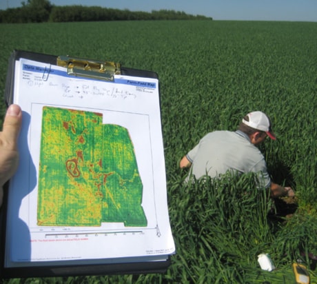
Images from satellites and airplane-mounted cameras can be used to create “bio-vegetative intensity maps” with which to assess crops, said Rob Saik, founder and CEO of The Agri-Trend Group of Companies. They can also provide precise altitude measurements for drainage projects.
Soil texture and salinity can be measured using special discs that emit electrical pulses while being pulled through a field. Yield maps, prepared from data collected during harvest, can identify location-specific nutrient needs.
There’s also the time-honoured practice of soil testing.
“There are all these technologies that are converging on farm right now,” said Saik, “and quite frankly, a lot of guys are just overwhelmed trying to make it all work.”
Red Deer-based Agri-Trend — which consists of Agri-Trend Agrology Ltd., Agri-Trend Aggregation Inc., Agri-Trend Marketing Inc. and Agri-Trend Data Corp. — has responded by adding a high-tech company to its roster: Agri-Trend Geo Solutions Inc.
“Its intent is to bridge the gap that exists between the technologies that are available today and practical implementation on farm,” said Saik.
“Some of the services are very interesting,”
For instance, bio-vegetative intensity maps enable producers to intervene during the growing season.
“You can see in real time what the intensity of the crop is and then make decisions for the application of foliar fertilizer or even pesticides on that crop, based on the intensity of the vegetation,” he said.
Such aerial data should be “ground-truthed,” he added, perhaps by way of plant tissue testing. From there, an application map can be plugged into a GPS-guided sprayer to ensure the precise application of inputs.
“If we found out that boron, for example, was low in a canola crop, we actually could go in and prescribe and foliar-apply boron in season on that crop.”
Or, a farmer planning to spray a fungicide could use a bio-vegetative intensity map to identify areas upon which to concentrate.
“You put your money where the crop is heavy,” said Saik, pointing out that this saves money and has environmental benefits.
The more data available, the better, he said. For instance, yield maps are more reliable when based on multiple harvests and combined with other methods of testing.
“A lot of people are just grabbing one set of data and determining that that data is accurate, when in fact it may be extremely skewed.”
Agri-Trend Geo Solutions grew out of an existing Calgary company called GeoFarm Solutions Inc.
“We collaborated and pulled that entity into this new one,” said Saik.
Based in Calgary, Agri-Trend Geo Solutions will be headed by Warren Bills.
“Geo-coaches” with the company will work directly with farmers, as well as with ag-related businesses like fertilizer, crop protection and seed companies, and equipment retailers, said Saik. They will provide the technical support needed to collect precision farming data, with agronomists then making recommendations based on that information, he said.
hrichards@www.reddeeradvocate.com