Hilly, forested and wet Tasmania is regarded by many Australians as their most picturesque state, a kind of Vermont of the Southern Hemisphere. It is also the most economically depressed, which is one of the reasons the Tasmanian government has upended a great walking tradition - that natural beauty owned by the state should be open to all, at minimal cost, in the spirit of democracy.
Less than two years ago, the state’s Parks and Wildlife Service finished construction of the Three Capes, a 29-mile track that starts at one of Australia’s most important historical sites and takes in some stunning coastline.
The project includes custom-designed accommodations, a spectacular boat ride and miles of boardwalks smooth enough to skateboard on. Visitors can borrow books, binoculars and even yoga mats.
Such luxuries aren’t cheap. There is an entrance fee of nearly $400 to access a track which used to cost only blisters, sunburn and time. The venture has been a huge success. Almost 10,000 people paid to take the walk in its first year, funds that the state badly needs.
Open for less than two years, the track is already developing a reputation among Australians for fostering a kind of exclusive camaraderie. Tasmanian authorities haven’t started marketing it overseas, and only 2 percent of walkers are foreigners, a park ranger told us.
As a consequence of the hefty charge, the walk is full of professionals and young families in fashionable hiking apparel, toting the latest in sleeping-bag technology. There are few, if any, hardcore hikers to be seen.
The trail begins at Port Arthur, a village on the Tasman Peninsula, which juts out into the Southern Ocean from Tasmania proper. A tragic site in both history and modernity for Australians, Port Arthur was a brutal penal colony from 1833 to 1877.
The open-air prison, which now is an immaculately maintained national heritage site, is one of Tasmania’s top tourist destinations. In 1996, a young, mentally disturbed man from the city of Hobart committed Australia’s worst modern mass shooting at the site, triggering a period of national introspection.
The tragic backdrop provides a moody start to the Three Capes Track, which begins on water, rather than land. Only 48 people are allowed in each day, and all get started with a one-hour speedboat trip around the ocean inlet that used to be the penal settlement’s main route to civilization.
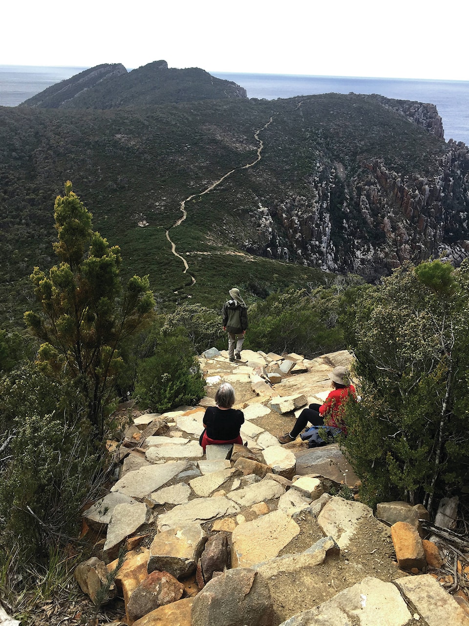
The ride was interesting and exhilarating. The crew provided facts about the geology, geography and sealife of the spectacular cliffs that dominate the area, then spun the boat so hard that seawater sprayed over us. We were deposited on a small, sheltered beach, where we began our walk through rain forests, woods, grassland, heaths and along sea cliffs - which we were told were some of the highest south of the equator - that plunged 1,000 feet into the ocean.
Even though there are 1,500-foot changes in elevation over several days, the Three Capes walk is easy enough for preteens and reasonably fit people in their 60s. The path is mostly composed of packed dirt and gravel or wooden boardwalks. Wooden benches overlook interesting views, including a rock ledge popular with seals at Cape Pillar.
Animals that make appearances along the walk include eagles, seals, dolphins, whales - and deadly snakes, although no one has died of Tasmanian snake bite in decades.
Tim Farrell, a 25-year-old Australian public servant I met on the trail, reasoned that the entrance charge has made the area more accessible by generating the funding needed to turn a sometimes-strenuous rocky trek into an easy-to-moderate walk. No roads extend into the area, which means that the materials for the track and huts had to be delivered by helicopter and assembled by workers living in temporary camps.
“It’s a necessary evil to allow so many people to explore the area,” Farrell told me one night in a heated, pristine dining hut while families sat around us playing Scrabble. “I like not being totally spent by the end of the day.”
Tim and seven friends had even ordered T-shirts for the walk with their own slogan: “Chafing the Dream.”
Each night, we stayed in a different cabin. Made from Tasmanian ash, they were in immaculate condition.
Each room has bunk beds. There are separate kitchen and dining areas, all with tap water, sinks, pots and pans, kitchen utensils and cleaning supplies. One site boasts a hot shower. There are mobile-phone chargers, too.
Yoga mats and lounge chairs can be used on the decks surrounding the cabins. Each site has a small library of Australian fiction and reference books, including two by Man Booker Prize-winning Tasmanian author Richard Flanagan. The collection is identical at each hut, to allow walkers to leave a book behind and pick it up again at the next location.
Every walker is assigned a hut from the start, which means there is no need to rush ahead to get the best room. (One night, on a bathroom run, I became disoriented and entered the wrong hut. I reached out to what I thought was my empty sleeping bag, which suddenly moved. I got out quickly.)
Each night, a resident ranger briefed us on the next day’s weather, local history and wildlife, and answered questions. They explained that one of their jobs was picking up excrement left behind by hikers who ignored requests to go well into the bush for bathroom stops.
The walk includes two capes with spectacular views: Cape Pillar and Cape Hauy. At Cape Pillar, it is possible to walk up a steep stone staircase and stand on a rock platform about the size of a child’s bed. Cliffs plunge on three sides to the sea below.
Although not particularly afraid of heights, I was almost hyperventilating from the walk up and view down. Even though it was spring, the mountains in the distance were covered with snow.
One night, I asked a ranger, Daniel, where the missing cape was on the Three Capes track. The question was, admittedly, a little cheeky.
“We get asked that question a lot,” the ranger said, sounding a little sheepish. “The third cape is part of the national park.”
Cape Raoul is located on the other side of Port Arthur and is too far away to be incorporated into the walk. Presumably, the Tasmania Parks and Wildlife Service felt that Two Capes didn’t sound impressive enough.
A private company is building its own cabins and plans to start operating a rival walk in September. For about $2,400, it will provide two guides, beds with linens and three-course dinners. The cheaper state-run walk doesn’t include food - although, it does provide toilet paper.
The Tasmanian government encourages the competition, which it hopes will eventually attract many of the foreign tourists who flock to the mainland’s sunnier beaches. The consequence could be a more glamorous crowd exploring the area.
- - -
Patrick is a writer based in Sydney. Find him on Twitter: @apatrickafr.
- - -
If you go
Three Capes track
6955 Arthur Hwy., Port Arthur
011-61-2-9975-4553
threecapestrack.com.au
Access to the Three Capes Track is controlled by the Tasmania Parks and Wildlife Service, which only accepts bookings online and charges about $390 for adults and about $312 for children. The four-day walk starts at the Port Arthur historical penal settlement, which is a one-hour ride by car or bus from Hobart, the state capital, and a popular tourist attraction in its own right. Walkers are required to stay in the provided huts, which have toilets, showers, cooking facilities and utensils. Food must be carried in. Each visitor is issued a detailed booklet containing walking notes and information on the area’s history, flora and fauna.