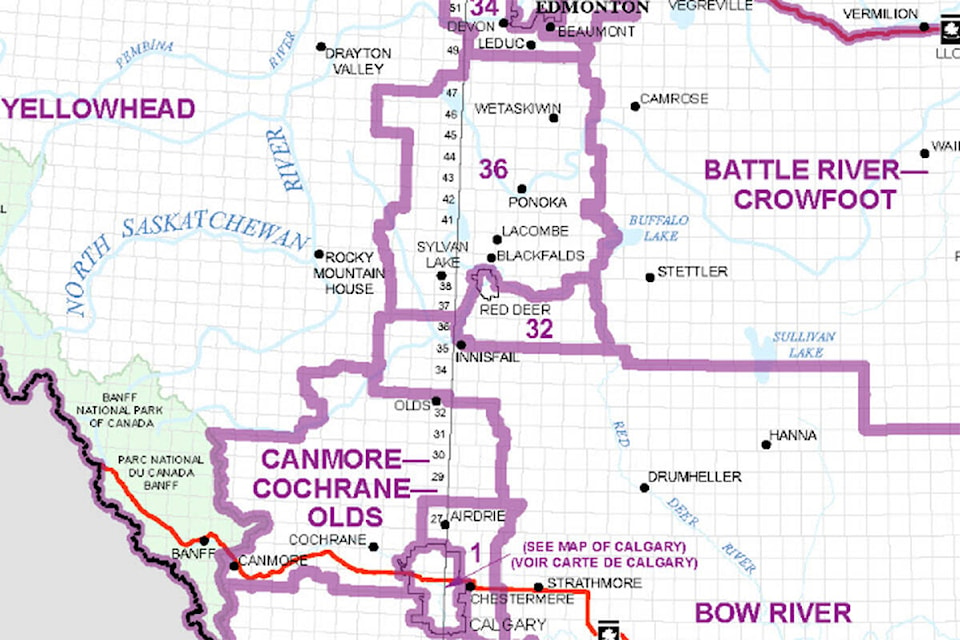
A proposed federal election map would create a single riding for Red Deer.
The Red Deer riding would include areas currently split between the Red Deer-Lacombe riding represented by Blaine Calkins and Red Deer-Mountain View represented by Earl Dreeshen. Penhold and Delburne would also be in the new riding along with the city.
A new Wetaskiwin-Lacombe riding would include Sylvan Lake and the communities north of Red Deer, Blackfalds, Lacombe Ponoka, Maskwacis and Wetaskiwin.
South of Red Deer, Olds will be part of a Canmore-Cochrane-Olds riding while Innisfail would be part of a huge Bow River riding that extends south to just north of Lethbridge and east to the Saskatchewan border.
The Federal Electoral Boundaries Commission for Alberta has extended the deadline for requesting an opportunity to speak at a public hearing on the riding changes to Aug. 15 from July 31. Hearings will be held on Sept. 21 in Olds and Red Deer.
The Olds hearing will take place at 1 p.m. at the Pomeroy Inn and the Red Deer hearing will take place at 7 p.m. at the Cambridge Hotel and Conference Centre.
The City of Red Deer used to be in a single riding — Red Deer — based on the borders of Red Deer County. It was split in a 2012 realignment of ridings. The seat was held by Dreeshen, who then became Red Deer-Mountain View MP. Wetaskwin MP Blaine Calkins became the Red Deer-Lacombe MP, which was originally meant to be called Red Deer-Wolf Creek.
Some concerns with the change were voiced at the time. Then-Red Deer mayor Morris Flewwelling wondered if the city’s urban concerns would be as well heard with the city split between two ridings with many smaller rural communities. By comparison, the cities of Lethbridge and Medicine Hat were both each contained within single ridings.
The latest proposal reflects the increase in Alberta’s population from 3,645,257 in 2011 to 4,262,635, as captured in the 2021 Census, and considers communities of interest or identity, and historic and geographic factors. The proposal can be found at redistribution2022.ca.
Under the Electoral Boundaries Readjustment Act, the commission’s main aim in redrawing boundaries is to divide the province into 37 electoral districts with populations that are as close to the electoral quota as reasonably possible while considering the relevant factors.
The electoral quota for each district is 115,206, which represents the result of the division of the total population of the province (4,262,635) by the number of electoral districts (37).