Earthquake experts have begun reviewing seismic data to determine the cause of Monday’s 4.6 magnitude quake.
Alberta Energy Regulator (AER) and Alberta Geological Survey (AGS) are reviewing the passive seismic data, which are naturally occurring low-frequency earth movements.
Those results will be checked against operational data from Vesta Energy Ltd., which was conducted fracking in the area to look for possible correlations, said AER spokesperson Natalie Brodych.
“The AGS will also investigate the subsurface conditions in the area to determine if they are vulnerable to induced seismicity.”
In other words, is there something about the ground in the area that makes it more vulnerable to fracking or other human intervention.
Brodych said there is no deadline when the investigations must be finished.
“This is the process that we follow when determining whether an earthquake is caused by hydraulic fracturing or natural causes,” she said.
“Past investigations led to the implementation of Subsurface Order No. 2 for the Duvernay formation in the Fox Creek area.”
That order came in response to an increase in earthquakes in the Fox Creek area beginning in 2013. AER issued a series of regulations requiring fracking companies to report any earthquakes within five kilometres of their operations. Companies must also assess the potential for earthquakes prior to work, and must have a response plan if an earthquake is reported.
AER says it may extend the order to other areas of the province if similar earthquake activity is detected. None of the earthquakes in the Fox Creek area have caused damage and most have not been noticed by residents.
An interactive map at www.aer.ca on AER’s website shows minor earthquakes are common in Alberta, mostly on a line along the Rocky Mountains and the Foothills. They occur within the thrust-fault systems that can be traced to the ancient mountain building processes that created the Rocky Mountains.
However, there are several areas where earthquakes have clustered. One is 30 km southwest of Rocky Mountain House and another is 90 km northwest of the town. Other clusters are near Fox Creek and Cardston.
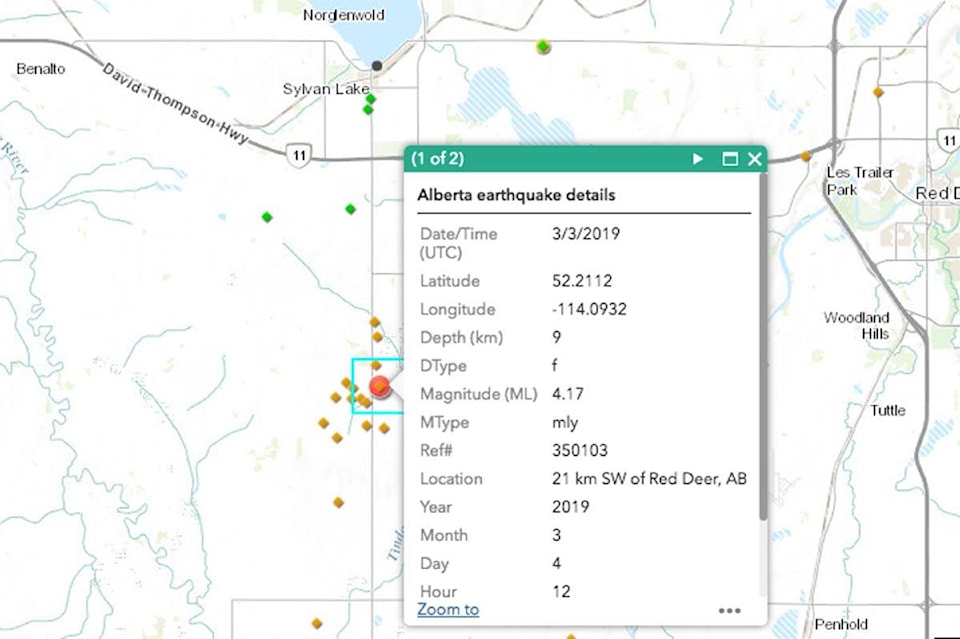
Monday’s quake south of Sylvan Lake shows up on the map as a 4.17 magnitude. More than a dozen other minor earthquakes — mostly below magnitude 2, which are usually not felt by anyone — were recorded in the hours before or after, according to the map.
Seismic experts have linked fracking to earthquakes. In Alberta, increased seismic activity in normally quiet areas around Cardston and Fox Creek have been “tentatively linked” to fracking, says the AER’s website. The Alberta Earthquake Studies Project is trying to better understand any connection.
In general, there has been an increase in earthquakes in Alberta since the late-1970s. Some of that is because there are more monitors catching smaller quakes, which previously went undetected. But there has been a significant increase in earthquakes with a magnitude of two or more, which would have been detected previously and cannot be attributed to new monitors.
Natural Resources Canada is collecting information on earthquakes and invites people to make a report at www.earthquakescanada.nrcan.gc.ca University of Calgary researchers have also taken an interest in the latest quake and urging people to report their experiences.
pcowley@reddeeradvocate.com
Like us on Facebook and follow us on Twitter