With Sunday’s severe weather alerts safely behind everyone, there’s one message City of Red Deer Emergency Manager Karen Mann would like to reiterate: Get prepared!
Late Sunday afternoon and into the early evening, numbers of weather watches and warnings, ranging from severe thunderstorms to actual tornado warnings, were issued by Environment Canada.
While local authorities are able to trigger the Alberta Emergency Alert system themselves, the one exception is for tornadoes, said Mann. These alerts come directly from Environment Canada.
Severe weather was forecast over a broad area of Central Alberta on Sunday, beginning in the Rocky Mountain House and Sundre/Caroline areas, and moving easterly with the active storm system, setting social media abuzz.
At its height, there were tornado watches issued for Red Deer and area, Sundre, Stettler, Lacombe and Three Hills areas. Sunchild O’Chiese, Rocky, Caroline, Spruce View, Pine Lake and Three Hills were some of the areas that actually received tornado warnings.
It’s one thing to receive information about watches and warnings but it’s another to know what to do when that information exists, Mann said.
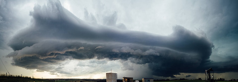
Lots of motion! North of Rocky Mountain House, Alberta #abstorm @PrairieChasers 6:03PM pic.twitter.com/tKjLttqbor
— Braydon Morisseau (@BraydonMoreSo) July 10, 2017
“OK, a tornado warning is in place. Now what?” The city wants residents to be equipped to respond to that information so that they already know where their safe place is and their emergency kit is in place. Both Environment Canada and the city provide emergency preparedness information, as well as what to do during severe weather.
Sunday’s Environment Canada weather summary indicates there was a probable tornado east of Sunchild at 5:01 p.m. but there was no damage reported and it was given the lowest rating on a zero to 5 scale.
There was hail throughout Central Alberta, ranging from ping pong-size in Rocky Mountain House, to golf ball-size in Innisfail and tennis ball-size north of Leslieville.
Dan Kulak, regional meteorologist with Environment Canada, said Monday there has been a problem possibly for decades with people understanding the difference between watches and warnings, as well as other public alerts such as special weather statements, advisories and so on.
Social media reports were indicating Red Deer had received a tornado “warning”, however that was never the case on Sunday. Despite what was being reported, the City of Red Deer was never under a tornado warning.
“A watch is head’s up, watch the sky. Be prepared for something. A warning is duck, it’s coming!” Kulak said.
Red Deer reached a high or 28C in Red Deer at 5 p.m., just prior to the storm system moving through the city with mainly rain, lightning and some wind.
The system brought cooling temperatures, so that the ongoing heat wave took a break, but not likely for long. A high of 19C was forecast for Monday and Tuesday with risk of thunderstorms, but Thursday and Friday the forecast is showing a high of 28C, and by Saturday, the temperature could reach 31C.
For more information about emergency preparedness go to the city’s website at reddeer.ca, click on City Services, then Ambulance Fire and Emergencies.
Also, detailed information is available online through the federal government at getprepared.gc.ca
barr@reddeeradvocate.com