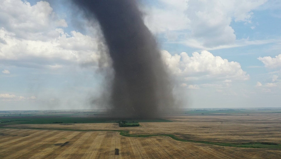
A landspout tornado touched down near Stettler on Wednesday.
Dramatic images of the tornado just north of the small community of Botha around 4:30 p.m. were captured by a number of storm chasers and other eyewitnesses and soon made the social media rounds.
The tornado last about six minutes or so before it dissipated, said Environment and Climate Change Canada meteorologist Jesse Wagar. There were no reports of damage.
A preliminary investigation suggests it was a landspout tornado, said Wagar.
“We still need to do a little bit of investigation to confirm that, but as it stands now it’s being classified as a landspout.”
Environment Canada specialists will comb social media for images and videos of the tornado as well as those sent to them directly and review radar and satellite images as part of their investigation. Since the tornado did no damage it is not likely Environment Canada will send anyone to the scene to gather information.
There are two types of tornadoes, landspouts and supercells.
“Landspouts are pretty weak typically, where supercell tornadoes are the big, violent, very dangerous type of tornadoes.”
The difference is in how they are formed and what type of thunderstorm they are associated with, she added.
The Stettler-area tornado was formed by a relatively weak developing thunderstorm.
“What happens is these landspout tornadoes from essentially from the ground up. There is already rotating air near the surface and then you get a weak thunderstorm that sets up over top of that and stretches that column and then you get a landspout tornado.
With a supercell tornado, the internal dynamics of the supercell thunderstorm create the tornado that then reaches out to the ground.
“It’s two totally different mechanisms for developing a tornado.”
Another indicator that a landspout happened was how quickly it dissipated when the nearby storm clouds moved on.
“That’s another classic indicator that it’s a landspout tornado instead of a supercell tornado. A tornado associated with a supercell will continue with the thunderstorm.”
While landspouts are less dangerous, for most observers they are indistinguishable from the more dangerous supercell variety and meteorlogists warn anyone who is in their path or nearby to take precautions and get under cover if necessary.
That was not the only dramatic weather seen in central Alberta on Wednesday. A hailstorm that formed near Rocky Mountain House in the mid-afternoon and tracked slowly across the province in a northeasterly direction brought hailstones ranging from nickel- to golf ball-sized near Pigeon Lake before it merged with another storm in the late evening northeast of Edmonton.
The storm crossed Highway 2 south of Edmonton around 7:30 p.m.
“That was actually a long-lived thunderstorm that went on quite a cross-Alberta adventure,” she said.
“There were no tornado reports from that one, but that one was a supercell. We had two totally different environments in Alberta (Wednesday).”