On a rare, sunny June day in 2005, June 16, I naively went west to carry on my tradition of catching a big trout on Father’s Day. I had not realized what had been going on, but I soon found out: muddy water was close to boiling over the Red Deer River Bridge west of Penhold on Hwy 592.
On Hwy 54, water was oozing over the pavement at the Medicine River Flats and a crowd was gathered at the Dickson Dam viewpoint to marvel at and photograph the whole flooded valley and frequent 10-metre standing waves at the foot of the wide-open spillway.
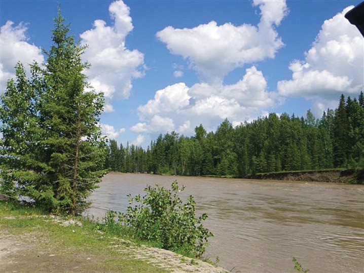
Hwy 54 just skimmed the surface of the new lake at Raven, where the Raven Rivers join; and the usually tiny, clear and gentle North Raven was a valley-wide lake as far upstream as I could see: obviously a raging Clearwater River had bullied the tiny, west-flowing Clear Creek into reversing itself and flowing east into the North Raven, thus joining the North Saskatchewan and Red Deer watersheds.
The campground at Clearwater Trading beside the river was totally awash, and when I crossed Prairie Creek, brown water was roaring out of my hayfield and over the pavement. The hayfield beside the creek was full and flowing from 1.5 to three metres deep, with just the odd fence post top poking above the surface. At the Stump Ranch, the rain gauge had overflowed at 200 mm in two days.
So, when I got the word on June 22 this year that 260 mm of rain had fallen in 36 hours on considerable snow pack in the Red Deer headwaters, I just had to repeat that 2005 trip to see if it was deja vu all over again: it wasn’t … quite. The floodplain below the Red Deer’s Penhold Bridge was not quite as high as in 2005; the valley below Dickson Dam was not quite as full, and the standing waves at the foot of the spillway were half as high as in 2005.
There was no lake at Raven, just a low, clear North Raven flowing into a high, fast and muddy South Raven, both within their banks, as were the Clearwater River and Prairie Creek. On my reverse run by the North Raven’s source springs, the Clearwater flood was just high enough to reverse Clear Creek, but not enough to push it into the North Raven, which remained probably the only fishable flowing water in Alberta. In fact, angler reports indicate the North Raven has been fishing very well post-flood.
When our bigger rivers recede enough to approach safely, the faithful goldeye will provide the fishing. I learned that goldeye love brown water when I was a kid fishing a mud puree irrigation drain into the Bow River near Bow City and caught goldeye that were rising for golden stoneflies among the bankside blooming wild roses. Otherwise, huge floods harm river and stream trout fisheries, taking the surviving big spawners eight years to breed the fishery back to where it was before the flood.
Reader reports to me from the south are of high, “scary” rivers and streams, washed out roads and marooned campers, but generally not as bad as in 1995 and 2005. But we all feel the horror of what the Bow and Elbow floods have done to Calgary and the Highwood to High River: expert observers tell me that severity comes from torrential rains combined with a deeper melting headwaters snow pack than in the rest of the province.
So what name will we give to this 2013 flood? The hydrologists told us 1995’s was the “flood of the century” and 2005’s was the “200-year flood,” and there was an anonymous high and hard one in 1990. In fact, there have been occasional horrendous floods on the Red Deer since the memory of man “runneth not to the contrary,” before dams and even before logging was done selectively and by hand, let alone clear cutting.
My Central Alberta river memory runs back only 50 years with a few big floods, mostly in June, when heavy snow melt and torrential rains occasionally combined forces. But I can’t recall either the frequency or the force of the floods we have endured in the past two decades. So what’s new, besides “climate change,” formerly known as “global warming?”
Can it just be coincidence that it is only two decades since we really got into clear cut logging in Alberta, too uncontrolled, and too often too close to and on steep slopes above headwaters streams, leaving nothing to soak up and slow down heavy runoff?
Perhaps, perhaps not, but in this I believe: Rape the headwaters and reap floods.
Even in Bangladesh, the poorest country on Earth, where they need not bother naming their yearly floods, they recognize that one of the causes is the deforestation of the headwaters of their three main rivers.
Bob Scammell is an award-winning columnist who lives in Red Deer. He can be reached at bscam@telusplanet.net.