TORONTO — People across central and eastern Canada hunkered down to face powerful winds and a deluge of rain as approaching superstorm Sandy hit the U.S. and gradually wheeled its way north.
The impact of the weather system extended over a thousand kilometres away from the storm, according to the Canadian Hurrican Centre, with southern Ontario and Quebec experiencing high wind gusts and periods of heavy rain on Monday night.
In Toronto, police said a woman had been killed by a falling sign as strong winds whipped the city. A spokesman said witnesses reported the woman was struck while walking through a parking lot as winds gusted around 65 kilometres per hour.
The Hurricane Centre said northerly winds were increasing over southern Ontario Monday night, with some areas reporting gusts above 80 kilometres per hour which were expected to get stronger. Meanwhile, south western Nova Scotia was also being whipped by gusty winds.
Officials warned residents in Ontario, Quebec and the Maritimes to prepare, though the East Coast of the United States was expected to bear the brunt of the unusually large storm.
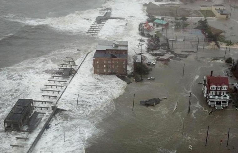
Sandy, which forecasters downgraded from a hurricane to an intense post-tropical storm, made landfall in New Jersey early Monday evening. It was expected to continue to churn north and northwest, lashing parts of Canada Monday night.
Forecasters warned that the change in the storm’s status was purely technical, based on its shape and internal temperature. It still packed hurricane-force wind, and remained dangerous to those in its path.
Southern Ontario and Quebec were expected to see the strongest winds, with gusts up to 100 kilometres per hour and between 20 to 40 millimetres of rain, although higher amounts were possible in some areas.
That will make for a soggy Tuesday, but that level wasn’t enough to trigger a rainfall warning.
Starting Tuesday morning, the Maritime provinces will see a lot more rain — up to 50 millimetres — and weaker winds than Ontario, though still strong at an expected 70 kilometres per hour.
The precipitation could turn into snow over parts of Ontario and western Quebec, said Environment Canada.
But it’s not the force of the winds or the amount of rain that sets this storm apart from others, it’s the sheer size of it, said Canadian Hurricane Centre spokesman Bob Robichaud.
“Usually a tropical system is a bit more compact than this and it doesn’t affect quite as large an area,” he said.
“This particular system is going to affect everywhere from southern Ontario, even into northern Ontario, and all the way to the Maritimes.”
The storm is also expected to whip up the water, generating waves of up to seven metres in Lake Huron. The Quebec Storm Prediction Centre issued storm surge warnings for pounding waves in the Gaspe and north shore of the St. Lawrence River. The south shore of Nova Scotia could also see several-metre high waves.
Public Safety Minister Vic Toews said in a statement that the military and the Canadian Coast Guard are on standby. Health Canada is conducting generator checks and has reviewed the National Emergency Stockpile, he said.
The stockpile, maintained by the Public Health Agency of Canada, contains supplies such as beds, blankets and antibiotics.
John Byrne, the director general of disaster management for the Red Cross, said the organization had 550 volunteers on standby in Ontario and the Atlantic provinces.
Utility companies in Ontario were preparing for the onslaught of the storm by having crews ready to respond to any calls about damage. By Monday night, more than 15,000 customers were without power in the province.
Emergency Management Ontario warned the storm may result in flooding, road closures and power failure. It said people should put away any objects that can be blown away by wind, such as garbage lids and Halloween decorations, to prevent damage or injury.
Nova Scotia’s Emergency Management Office said residents who live along the coast should watch out for pounding surf and high winds, particularly in the southwestern corner of the province.
In Fredericton, that city’s Emergency Measures Organization told residents to keep catch basins near their homes clear of leaves and other debris to prevent localized flooding.
Hundreds of flights leaving from airports across Canada bound for the U.S. East Coast were cancelled. At Toronto’s international airport, one-quarter of all of flights departing Monday were cancelled.
Airlines advised travellers to check the status of their flight ahead of time.
Sandy was blamed for more than 60 deaths as it churned across the Caribbean.
In the U.S., thousands of people from Maryland to Connecticut were ordered to leave low-lying coastal areas, including 375,000 in lower Manhattan and other parts of New York City, 50,000 in Delaware and 30,000 in Atlantic City, New Jersey, where the city’s 12 casinos shut down for only the fourth time ever.
President Barack Obama declared emergencies in Massachusetts, Connecticut, Rhode Island, New York, New Jersey and Pennsylvania, authorizing federal relief work to begin well ahead of time.
In an attempt to lessen damage from the storm, New York City’s main utility cut power to about 6,500 customers in lower Manhattan. Authorities worried that seawater would seep into the New York subway and cripple it, along with the electrical and communications systems that are vital to the nation’s financial centre.
Major U.S. financial markets, including the New York Stock Exchange, planned a rare shutdown for a second consecutive day Tuesday. The United Nations also shut down Monday.